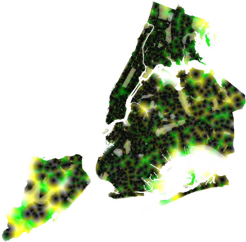
Count every bench, bus shelter, plaza and park the city records, and 18 percent of the land where New Yorkers live is more than a five-minute walk from a place to sit. On Staten Island it is 47 percent.
Loading the seat inventory…
Each square of color is about 60 meters on a side. Walking time is the straight-line distance times 1.25, to allow for the street grid. Dots appear when you zoom in.
Source: DOT Seating Locations (esmy-s8q5). The year comes from each record's site number (SEAT.2024.0001 and so on), which matches the installation date within a year on 96 percent of the records that have both and is filled in on records that have no date.
| Neighborhood | Borough | 2020 population | Median minutes, any seat | Street seats | Backed benches | Land beyond 5 min, any seat | Bus shelters | Street seats |
|---|
Walking. The city's land is cut into squares about 60 meters on a side. For each square, the page finds the straight-line distance to the nearest seat, multiplies it by 1.25 to allow for walking around blocks, and converts it to minutes at 3 miles an hour. Three miles an hour is a typical adult pace. Many older people walk closer to two, which is why the map has a slower setting; the federal traffic-signal manual (MUTCD section 4E.06) times crosswalks for 3.5 feet a second, about 2.4 mph, and allows slower for places with many slower walkers. The 1.25 detour factor is an assumption, not a measured street-network distance.
Where people live. Land-share figures count only squares inside the 197 residential Neighborhood Tabulation Areas and outside park property, so a big park does not count as a seatless place where people live. They are shares of land, not of people: a square of single-family houses counts the same as a square of towers.
Parks. NYC Parks does not publish a bench inventory. The "any seat" measure treats being inside, or at the edge of, a park of a kind that nearly always has benches (neighborhood, community and flagship parks, playgrounds, sitting areas, malls and similar, 1,433 properties) as being at a seat. Community gardens, nature areas, strips, parkways and undeveloped land are left out. This is the most generous reading of the parks; inside a large park the nearest bench can be farther than its edge.
Bus shelters. DOT says that "all of the city's bus shelters offer seating" (street furniture page). The shelter file (t4f2-8md7) has no bench field, so each of the 3,312 shelters is counted as a seat.
Leaning bars are a rail to prop against, 8 feet long and about 2 feet 11 inches high, per the Street Design Manual. They are counted in the backrest chart and shown on the map but never counted as a seat. "World's Fair" benches (28, all on Surf and Mermaid avenues in Coney Island) are treated as backed; the data dictionary does not define the type, and the style comes in versions with and without backs.
What the data can't tell you. The DOT file has 5,776 records, but DOT's own seating page describes "over 2,600 benches and leaning bars"; the file may include removed or planned sites, and nothing in it says which. Privately owned public spaces are counted when their permits require seating, which is not the same as seating being out today, and 82 of the 217 list restricted hours for at least part of the space. Library steps, stoops, café chairs, Open Streets and seasonal Street Seats are not in any of the files used here.
The first version, published earlier on Nov. 6, left out bus shelters and parks, which made most of Queens and Staten Island look far worse than they are; said 877 recent benches were missing both a type and a date when about 600 more had a type but no date, and drew those as unclassified; listed the wrong breakdown of the 877 by year; called 177 neighborhoods residential when there are 197; offered a "zero backed benches" filter that matched no neighborhood; gave the wrong mix of seats for Midtown–Times Square; and used three different citywide totals. All are corrected here.
Neighborhoods (CSV) Boroughs (CSV) DOT installs by year (CSV) All seats (JSON) Walk-time raster (PNG) Raster key build_data.py Methodology